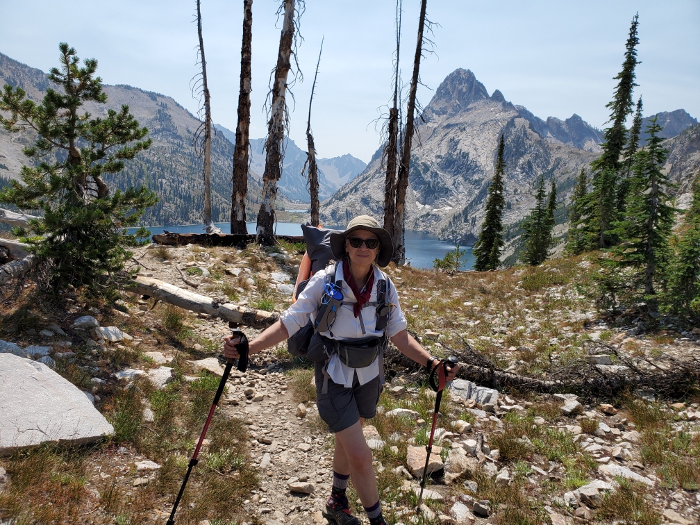
 Melanie w view of Sawtooth Lake
My friend Christine had researched and hiked this route about seven years ago. The photos she shared were magnificent and I immediately put this trail on my to do list. After my injury which bounced me off the Hayduke this spring, I planned the Grand Sawtooth Loop as a great hike to do once I recovered. It would also be a good test for Yeti – a first backpacking trip since his mitral clip surgery last November.
Yeti and I drove down to Idaho on the 2nd of August, stopping in Salmon (a favorite trail town) at a great new bakery (Odd Fellows) for coffee on the way. We arrived at the Grandjean campground by 2pm and decided we’d hike in a few miles and camp instead of trying to secure a spot in the crowded campground.
Heading up clockwise for over 1,000 feet, we found a flat-ish spot near a creek about 2.5 miles in. We had a nice night here, very quiet and out of view of the trail.
In the morning, we headed up the mountain, a climb of about 2,000 feet. We decided to by-pass Trail Creek Lakes since we didn’t plan to camp there, and it was a 1.4 mile off trail side-trip with an additional 700–800-foot climb. We also skipped Observation Peak. It was a good idea not to overburden Yeti’s heart. He did well with the climb. Slow and easy. A nice breakfast stop by a creek was a highlight of the morning.
The many alpine lakes are the great feature of this route. Our first amazing lakes included the chain of McGowen lakes/ponds and then the dramatic Sawtooth Lake, which you reach after a series of steepish switchbacks downhill. The lake is surrounded by jagged cliffs. We lunched there amid a swirl of day-hikers who can reach the lake via the Iron Creek Trail. Our first on-trail camp came after a long downhill with switchbacks and a “bushwhack” through overgrown brush down North Baron Creek canyon. We stopped at the trail junction where there is a nice campsite (13.4 miles). At about 9pm, the wind picked up and we could hear thunder in the distance, but we did not get any rain.
The next section began the best part of the loop. My favorite lake came soon, Lower Baron Lake. It was stunning, smaller than Sawtooth, but in such a great setting. To reach Baron Lake, we climbed up through forest, then on rocky switchbacks passed Baron Creek Falls, another amazing scene. After some light rain in the morning, the afternoon turned sunny, and we spent two ½ hours at lunch at the lake. We bumped into a couple from Syracuse, NY and talked to them for quite some time. After the lake, you climb up to 9150 feet to the Baron Divide, which had spectacular views into the next canyon. Camp was Alpine Lake (9.9 miles) unfortunately very heavily impacted by campers. We were interviewed on camera by Pearce, a young man who was doing a video on the Sawtooth for Outside TV.
After Alpine Lake, you descend on switchbacks to Flat Rock junction, fording a shallow creek. We had breakfast here, thankfully, as it soon started to get dark and ominous as we continued. This was the wet day, with thunderstorms overhead and lightning. We hiked through rain, hail, and wind for over 2 ½ hours. Finally, after stopping to layer-up (the temperature had dropped quite a bit) it began to let up. We were climbing to a high pass and slowly but surely the sun peeked out. Taking advantage of the sun and warmth, we cooked lunch and dried out as best we could in a scenic flat area near two ponds part way up to the pass. Luckily for us, the remaining part of the day was dry! We made it to Virginia Lake at about 5pm (10.9 miles), and I really wanted to stop. Good that we did. No sooner had we set up and started to cook than it began a very light piddle of rain. We were able to finish our meal, but no sooner had we gotten back to our tents it started to rain again steadily. Oh, well, wet tents in the a.m.
Edna Lake and Vernon Lake were also very charming, and Ardeth Lake was stunning in a circle of ragged peaks as you descended into the basin. Spangle Lake and Lake Ingeborg are also very nice, followed by the smaller Rock Slide Lake. This was a big climbing day, but Yeti did well. Taking it slowly, we managed the climbs and enjoyed the spectacular views of the Sawtooth’s signature jagged mountains. After yesterday’s rain, it was nice to have a gorgeous, cooler, and relatively smoke-free day. We were counting on a campsite that the guidebook mentioned along a creek after coming off another high pass. But, though we clocked the mileage on our GPS, it never materialized (the book was wrong on other mileages, as well), so we found a flat spot in the woods near a further creek that we saw on our Backcountry Navigator program (12 miles). It turned out to be a nice spot and we passed a quiet night. This day, we had only seen a couple in the morning…no other hikers. The other days we’d seen quite a few hikers.
It was obvious that we were going to finish the hike in less than the seven days allotted. Our strategy for the next day was to hike to a spot a few miles from the trailhead and walk in the following morning early. Again, we were relying on the guidebook which mentioned a campsite after Goat Creek. This day was quite different from the previous terrain in the higher mountains. Our hike took us through a charming canyon. We loved Fern Falls, two dramatic cascades in a very rocky area. The creek roared through narrow spaces…I love flowing water! Then, we had to navigate a rockslide….it was cairned so not hard to find the trail on the other side. You just had to step carefully among the rocks. It was easier hiking now, mostly downhill! It seemed to take forever, though, to reach our camp. We got to Goat Creek, where there had clearly been a lot of flooding. Over the creek, we found a “sandy” spot secluded from the trail and set up tents there. Yeti and I cleaned up in the beautiful creek…the sun warmed the rocks and glistened over the water. We spent a great final night out here, quiet and peaceful. (12.8 miles).
The morning was quite cold…we think it was in the high 30s…I found frost on the tent. We only had about 3 miles back to the trailhead, which seemed to fly by. We did have to ford North Baron Creek, about shin-deep and COLD! My fresh socks didn’t stay dry long that morning. By the time we reached the car both of us were shivering and eager to get into our town clothes. We got the car going and heat on so we could warm up. Then off we went after this great hike to Stanley for a celebratory breakfast! Stopped again in Salmon at the bakery for sandwiches and continued home. A great trip and fantastic route. Yeti was very pleased with how he did on this trip which had lots of steep climbs…hardly an easy hike. Thanks to Christine for suggesting this trip!